
Property Information Management
Cohga’s Property Information Management System (PIMS) is a web application that integrates task management and financial reporting for land acquisition and compensation programs on major infrastructure projects.
PIMS provides better coordination, improved data management, and better handling of property based issues within the design, planning, finance, communications and property teams within and across agencies. This in turn drives down costs, improves accountability, reduces duplication and errors, and ultimately improves outcomes for claimants and authorities by allowing for faster and more confident decision making.
Capabilities
- Multi agency/project – PIMS can be configured for use by multiple agencies to cater for the differing business needs within the common property land management framework and legislation.
- Secure - Data is encrypted on the server and when travelling between client PCs and the server.
- Workflow driven – a common, well defined and easy to follow workflow is built into PIMS to allow the creation and management of Projects, Properties, Interested Parties, Titles, and Financial Transactions.
- Extensive reporting – an extensive library of reports is available to report on cases, projects, finances, expenditure forecasts, cash reconciliation, and much more. Reports are parameter driven providing flexibility and control for the end user.
- Mapping capability – the map interface brings together project specific layers and other generic layers common to all projects. This functionality allows users to quickly locate a property, its proximity to project design and boundaries and understand its full context in respect of an infrastructure project or locality.
- Audit trail – behind the scenes the system captures all operations. PIMS provides an interface to administrator users to view and report on this information within the application.
- System Administration – PIMS comes with an extensive Administration capability to allow the set up and management of all aspects of the system, including users, projects, reports, help text, and more.
- Web application – PIMS is a client / server web application with a modern user interface that can be run on any platform and any modern web browser.
- Role based security – access to data, function and reports is controlled by roles assigned to users and activated on login to the system ensuring stakeholders only see the information they need. Single Sign On can also be configured.
- Case management – case negotiators and managers are able to conduct all their relevant activities and report on outcomes associated with land acquisition on a case by case basis. The My Cases form provides a great summary of all the cases being worked on by a case negotiator.
- Financial management - PIMS captures a range of standard land expenditure cost components to enhance future project estimating by comparing budget components to actual costs. PIMS also captures Offers and Claims for acquisition, tracking at component level so case managers can see exactly what the breakdown is. Individual components can be accepted or rejected. PIMS forecasting provides case managers with a snap shot comparison of budget, forecast/accrued expenditure, cash transactions and the Total Forecast (TEC). It also provides project reports summarising the overall project financial position.
- Highly configurable – PIMS allows the configuration of most UI elements, giving system owners the ability to update without code changes.
- Data Import/Export - capture of initial property data sets is commonly undertaken in Excel spreadsheets. PIMS has bulk data upload functionality to import and create database records from CSV text files generated from Excel. Like-wise database records can be exported to Excel for further data analysis and ad hoc reporting.
- Flexible hosting - PIMS can be hosted in the cloud, on premise, or a combination of both.
Proven Business Benefits
- Better coordination, improved data management and better handling of property-based issues within the design, planning, legal, finance, communications and property teams of an agency;
- Integration of spatial and aspatial (tabular) data in one enterprise application;
- Capacity to better align and target data work flows across portfolios, and escalate the delivery of joined-up services;
- Sharing of data intelligence among a broader team audience, leading to new ideas around its use;
- Greater access to property-based information to reduce duplication of effort, and to target resources;
- Places agencies in a strong position to respond to the increasing property management needs of government, industry and the community;
- Greater recognition of and demand for high quality property information;
- Greater alignment between policy and service delivery agencies and organisations (government at all levels, utilities and the private sector) using property information as a common denominator;
- Increased commitment to greater team participation, better access to information and improved service delivery for agencies.
A New Generation
In late 2025, Cohga implemented the second generation of the system – officially known as PIMS2. With a refreshed user interface that enables the logical layout and display of complex information, deeper finance data capture and presentation, a better task management and planner system within the application, and improvements and enhancements to the backend to ensure extensibility and scalability for the future.
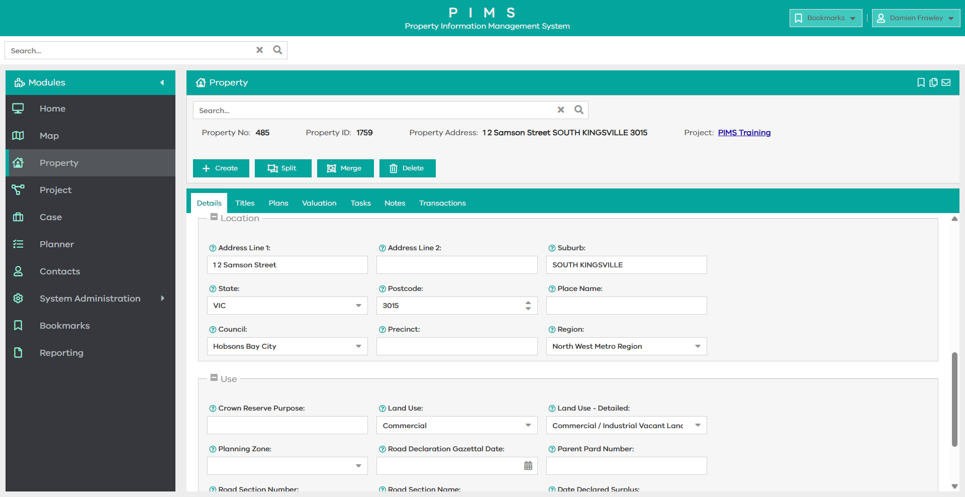
Property
The heart of the system – the Property module tracks all details for a piece of land from the address details, area, current land use, traditional owners, as well as associated data such as titles, plans, and valuations. The Transactions tab show all transactions for the property such as acquistion, or sale. Tasks can be generated for anything to do with the property from this module and notes can be added against several categories as needed
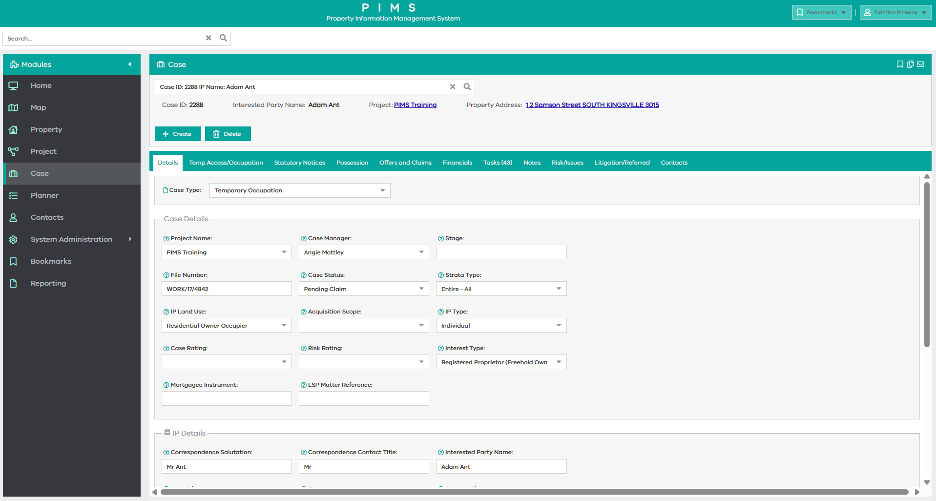
Case
A case is a transaction on the property and captures details such as who is managing it, stage and status, and details of the interested parties. For each case, other module tabs will become available depending on selections made (business rule driven). The all important finance module is a staple and shows offers and claims for acquisitions as well as invoices and expenditure on the case.
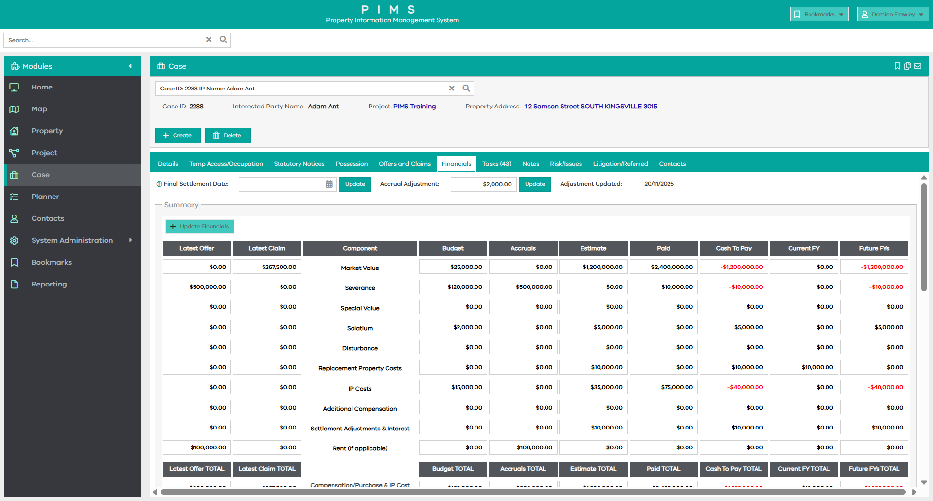
Expenditure & Cash Flow
PIMS2 expands the finance modules at a case and project level ensuring that budgets and estimates are captured. Invoices can be entered and taken through a cost approval process, and when approved automatically determine paid and accrual totals ensuring you always have an accurate and up-to-date view of the financial status at either level
Reporting
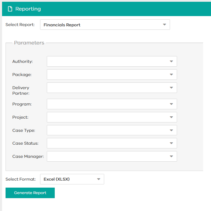
PIMS provides extensive reporting across financial, statistical and task management processes. Tailored reports with specified parameters allow users to focus data outputs as required.
As much of the property data starts life in Excel spreadsheets developed by client authorities, there is a bulk import and export report processes to create PIMS records from Excel files and then export updated records back to the clients for purposes such as mail merge correspondence.
Standard reports include:
- Financial
- Statistics by Property and Interest Types
- Milestone – Actions vs Program
- Supplier
- Bulk Import and Export
- Case Load
- Asset Register
- Property-Polygon Validation
Additional reports can be built and included as needed.
Unlocking project insight through spatial intelligence

The ability to visualise and interrogate project data spatially is a powerful driver of efficiency and informed decision-making. By presenting properties in their geographic context alongside key project elements, users can quickly understand relationships, assess impacts, and access detailed activity and financial information in just a few clicks.
PIMS delivers an intuitive, map-based interface that enables users to search for and identify properties using location, address, and other key criteria. From the map, users can seamlessly drill into rich property-level information, including ownership status, acquisition progress, and both actual and forecast expenditure.
The platform also supports layered map overlays of critical project data—such as road design, project boundaries, aerial imagery, and planning zones—providing a comprehensive spatial view of the project environment.
As a result, PIMS becomes a shared source of truth across project teams, supporting more effective communication, coordination, and decision-making for engineers, planners, and stakeholder engagement professionals.
A proven platform, tailored to your needs
PIMS is a mature, ready-to-deploy solution that has been refined through real-world use across complex projects. This means organisations can adopt the platform with confidence, benefiting from established functionality, proven workflows, and reduced implementation risk from day one.
At the same time, we recognise that every organisation and project has unique requirements. That’s why PIMS is designed to be highly configurable and extensible, allowing us to tailor the solution to align with your specific processes, reporting needs, and operational context, without compromising the integrity of the core platform.
Our commitment extends well beyond implementation. We work closely with our customers to shape an evolving product roadmap, with new features and enhancements driven by real user needs and emerging industry challenges. This ensures that PIMS continues to deliver value over time, while also providing customers with access to ongoing innovation that benefits the broader user community.
By choosing PIMS, you’re not just selecting a software solution – you’re partnering with a team dedicated to continuously improving the platform and supporting your success for the long term.